![](/images/other/stat-length.png)
![Trail On foot Bergisch Gladbach - O Rund um Berg.Gladbach-Herkenrath - Photo](https://media.geolcdn.com/t/1900/400/ext.pjpeg?maxdim=2&url=https%3A%2F%2Fmedia.geolcdn.com%2Ff%2F8357e86b-ec16-43aa-a2d3-3e1af5c24582.jpeg)
O Rund um Berg.Gladbach-Herkenrath
SityTrail - itinéraires balisés pédestres
Tous les sentiers balisés d’Europe PRO
![Length](/images/other/stat-length.png)
Length
7.4 km
![Max alt](https://static1.geolcdn.com/siteimages/upload/files/1508320355ic_sort_altitude_max_24dp.png)
Max alt
229 m
![Uphill gradient](https://static1.geolcdn.com/siteimages/upload/files/1508320355ic_sort_den_pos_24dp.png)
Uphill gradient
175 m
![Km-Effort](/images/other/stat-length.png)
Km-Effort
9.7 km
![Min alt](https://static1.geolcdn.com/siteimages/upload/files/1508320355ic_sort_altitude_min_24dp.png)
Min alt
124 m
![Downhill gradient](https://static1.geolcdn.com/siteimages/upload/files/1508320355ic_sort_den_neg_24dp.png)
Downhill gradient
168 m
![Boucle](https://static1.geolcdn.com/siteimages/upload/files/16400158638029165_repeat_loop_refresh_sync_direction_icon.png)
Boucle
No
Signpost
Creation date :
2022-02-11 12:47:10.464
Updated on :
2022-02-11 12:47:10.464
![On foot](https://static1.geolcdn.com/sitytour/trail-icons/100.png)
2h11
Difficulty : Easy
![Scan this QR Code to open this trail in the SityTrail application](https://capi.geolives.com/qq0zvz2zws4bq2lad0pu/sitytour/trails/3087877/qr.png?size=200)
FREE GPS app for hiking
About
Trail On foot of 7.4 km to be discovered at North Rhine-Westphalia, Rheinisch-Bergischer Kreis, Bergisch Gladbach. This trail is proposed by SityTrail - itinéraires balisés pédestres.
Description
Trail created by Sauerländischer Gebirgsverein.
Symbol: Kreis
Positioning
Country:
Germany
Region :
North Rhine-Westphalia
Department/Province :
Rheinisch-Bergischer Kreis
Municipality :
Bergisch Gladbach
Location:
Unknown
Start:(Dec)
Start:(UTM)
371031 ; 5649145 (32U) N.
Comments
Trails nearby
![Trail On foot Bergisch Gladbach - BASt Rundweg A2 - Photo](https://media.geolcdn.com/t/375/260/ext.jpg?maxdim=2&url=https%3A%2F%2Fmedia.geolcdn.com%2Ff%2Fc81d1256-cff1-40ad-9978-d43cbbb8cc9c.jpeg)
![On foot On foot](https://static1.geolcdn.com/sitytour/trail-icons/100.png)
BASt Rundweg A2
On foot
Easy
Bergisch Gladbach,
North Rhine-Westphalia,
Rheinisch-Bergischer Kreis,
Germany
![](/images/other/stat-length.png)
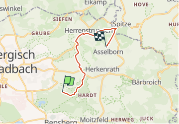
5.9 km | 6.9 km-effort
1h 34min
![](https://static1.geolcdn.com/siteimages/upload/files/16400158638029165_repeat_loop_refresh_sync_direction_icon.png)
No
![Trail On foot Bergisch Gladbach - BASt Rundweg A1 - Photo](https://media.geolcdn.com/t/375/260/ext.jpg?maxdim=2&url=https%3A%2F%2Fmedia.geolcdn.com%2Ff%2F2165c68b-ab60-47c2-b853-b1f87c326248.jpeg)
![On foot On foot](https://static1.geolcdn.com/sitytour/trail-icons/100.png)
BASt Rundweg A1
On foot
Easy
Bergisch Gladbach,
North Rhine-Westphalia,
Rheinisch-Bergischer Kreis,
Germany
![](/images/other/stat-length.png)
4.9 km | 5.6 km-effort
1h 16min
![](https://static1.geolcdn.com/siteimages/upload/files/16400158638029165_repeat_loop_refresh_sync_direction_icon.png)
No
![Trail On foot Overath - Steinenbrück Rundweg A2 - Photo](https://media.geolcdn.com/t/375/260/ext.jpg?maxdim=2&url=https%3A%2F%2Fmedia.geolcdn.com%2Ff%2Ff9384976-73ea-43d1-881f-62b07725c51f.jpeg)
![On foot On foot](https://static1.geolcdn.com/sitytour/trail-icons/100.png)
Steinenbrück Rundweg A2
On foot
Easy
Overath,
North Rhine-Westphalia,
Rheinisch-Bergischer Kreis,
Germany
![](/images/other/stat-length.png)
7.7 km | 10.4 km-effort
2h 21min
![](https://static1.geolcdn.com/siteimages/upload/files/16400158638029165_repeat_loop_refresh_sync_direction_icon.png)
Yes
![Trail On foot Odenthal - Höffe Rundweg A6 - Photo](https://media.geolcdn.com/t/375/260/ext.jpg?maxdim=2&url=https%3A%2F%2Fmedia.geolcdn.com%2Ff%2F118d5a55-83f1-46a3-ad05-d231629ccb1e.jpeg)
![On foot On foot](https://static1.geolcdn.com/sitytour/trail-icons/100.png)
Höffe Rundweg A6
On foot
Easy
Odenthal,
North Rhine-Westphalia,
Rheinisch-Bergischer Kreis,
Germany
![](/images/other/stat-length.png)
3.3 km | 4.8 km-effort
1h 5min
![](https://static1.geolcdn.com/siteimages/upload/files/16400158638029165_repeat_loop_refresh_sync_direction_icon.png)
Yes
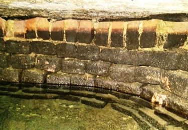
![Trail On foot Bergisch Gladbach - [U] Rundweg Asselborn - Schiff - Hombach - Photo](https://media.geolcdn.com/t/375/260/ext.jpg?maxdim=2&url=https%3A%2F%2Fmedia.geolcdn.com%2Ff%2F538de2de-e757-46d2-b801-d02da58106d2.jpeg)
![On foot On foot](https://static1.geolcdn.com/sitytour/trail-icons/100.png)
[U] Rundweg Asselborn - Schiff - Hombach
On foot
Easy
Bergisch Gladbach,
North Rhine-Westphalia,
Rheinisch-Bergischer Kreis,
Germany
![](/images/other/stat-length.png)
5.2 km | 6.8 km-effort
1h 32min
![](https://static1.geolcdn.com/siteimages/upload/files/16400158638029165_repeat_loop_refresh_sync_direction_icon.png)
No
![Trail On foot Bergisch Gladbach - Herrenstrunden Rundweg A1 - Photo](https://media.geolcdn.com/t/375/260/ext.jpg?maxdim=2&url=https%3A%2F%2Fmedia.geolcdn.com%2Ff%2F538de2de-e757-46d2-b801-d02da58106d2.jpeg)
![On foot On foot](https://static1.geolcdn.com/sitytour/trail-icons/100.png)
Herrenstrunden Rundweg A1
On foot
Easy
Bergisch Gladbach,
North Rhine-Westphalia,
Rheinisch-Bergischer Kreis,
Germany
![](/images/other/stat-length.png)
3.4 km | 4.6 km-effort
1h 2min
![](https://static1.geolcdn.com/siteimages/upload/files/16400158638029165_repeat_loop_refresh_sync_direction_icon.png)
Yes
![Trail On foot Bergisch Gladbach - Herrenstrunden Rundweg A3 - Photo](https://media.geolcdn.com/t/375/260/ext.jpg?maxdim=2&url=https%3A%2F%2Fmedia.geolcdn.com%2Ff%2F538de2de-e757-46d2-b801-d02da58106d2.jpeg)
![On foot On foot](https://static1.geolcdn.com/sitytour/trail-icons/100.png)
Herrenstrunden Rundweg A3
On foot
Easy
Bergisch Gladbach,
North Rhine-Westphalia,
Rheinisch-Bergischer Kreis,
Germany
![](/images/other/stat-length.png)
4.9 km | 6.5 km-effort
1h 28min
![](https://static1.geolcdn.com/siteimages/upload/files/16400158638029165_repeat_loop_refresh_sync_direction_icon.png)
No
![Trail On foot Bergisch Gladbach - Herrenstrunden Rundweg A2 - Photo](https://media.geolcdn.com/t/375/260/ext.jpg?maxdim=2&url=https%3A%2F%2Fmedia.geolcdn.com%2Ff%2Fb5681d97-5413-42fc-b1f7-728a89266cf4.jpeg)
![On foot On foot](https://static1.geolcdn.com/sitytour/trail-icons/100.png)
Herrenstrunden Rundweg A2
On foot
Easy
Bergisch Gladbach,
North Rhine-Westphalia,
Rheinisch-Bergischer Kreis,
Germany
![](/images/other/stat-length.png)
6.6 km | 8.3 km-effort
1h 53min
![](https://static1.geolcdn.com/siteimages/upload/files/16400158638029165_repeat_loop_refresh_sync_direction_icon.png)
Yes
![Trail On foot Odenthal - Höffe Rundweg A1 - Photo](https://media.geolcdn.com/t/375/260/ext.jpg?maxdim=2&url=https%3A%2F%2Fmedia.geolcdn.com%2Ff%2Feaed964f-6e82-4424-b080-beb0f759a0ac.jpeg)
![On foot On foot](https://static1.geolcdn.com/sitytour/trail-icons/100.png)
Höffe Rundweg A1
On foot
Easy
Odenthal,
North Rhine-Westphalia,
Rheinisch-Bergischer Kreis,
Germany
![](/images/other/stat-length.png)
3.3 km | 4 km-effort
53min
![](https://static1.geolcdn.com/siteimages/upload/files/16400158638029165_repeat_loop_refresh_sync_direction_icon.png)
No